Introduction to The Industrial Revolution

The Industrial Revolution (1820-1870) was of great importance to the economic development of the United States. The first Industrial Revolution occurred in Great Britain and Europe during the late eighteenth century. The Industrial Revolution then centered on the United States and Germany.
The Industrial Revolution itself refers to a change from hand and home production to machine and factory. The first industrial revolution was important for the inventions of spinning and weaving machines operated by water power which was eventually replaced by steam. This helped increase America’s growth. However, the industrial revolution truly changed American society and economy into a modern urban-industrial state.
The Industrial Revolution itself refers to a change from hand and home production to machine and factory. The first industrial revolution was important for the inventions of spinning and weaving machines operated by water power which was eventually replaced by steam. This helped increase America’s growth. However, the industrial revolution truly changed American society and economy into a modern urban-industrial state.
The Industrial Revolution
...
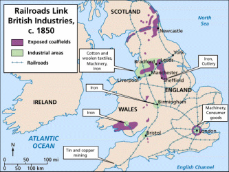
This map shows the major railroad lines in Britain during the mid-1800s. You can see how both raw materials moved to manufacturing centers and also how finished goods traveled to markets throughout Britain and to ports such as London (for shipment overseas.) Great Britain underwent a railroad-building boom between 1830 and 1850. In 1830, Great Britain had only about 375 miles of authorized railroad track. By 1850 the miles of track had drastically grown to over 8,000. This rapid growth of railroads helped to intensify the pace of industrialization. By this time, in Britain Cartographers had a relatively correct map that included a scale and legend.

This is a Topographical Map, as it shows the range of elevation from the mountains down to sea level. It is also colour coded to depict each state with distinct characteristics. The states of Alabama, Louisiana, and Carolina can be seen.
The map is derived from a 1746 map of North America, and was updated bringing it to the time of the 1776 American Revolution, the year this map was printed. The variation in colour shows the different states that the British settlers first settled on. By comparing the first map with this one, you can see the variation in advancement of cartographers depending on where you were in the world.
The map is derived from a 1746 map of North America, and was updated bringing it to the time of the 1776 American Revolution, the year this map was printed. The variation in colour shows the different states that the British settlers first settled on. By comparing the first map with this one, you can see the variation in advancement of cartographers depending on where you were in the world.

This is a Physical Map of North America. It shows the geography of the land. Made in 1797, it shows the desolate region of the West and the highly populated region of the East. It should be noted that there is no relation to how close Green Land is to North Eastern Canada. This map mostly just shows the topography of North America during the 1790's. It is interesting to find that this was a new map created by a cartographer at the time, showing how North America was thought to be. As said from the text on the bottom left of the corner of the map. We can assume that explorers have landed near the bottom right, as there is the most amount of text present at the bottom. The Bahamas and up to Newfoundland has been already described on the map, showing signs of colonization on these parts of the land.
The Worldview
During the Industrial Revolution, the 18th-century cartographers, relied upon a variety of sources. Despite their best efforts, inaccuracies abounded. Most often they consulted the work of other mapmakers; rarely did they conduct their own surveys. As a result mistakes carried over from one map to the next.
Politics also played a part in cartographers’ work, especially since most depended on a monarch or other influential aristocrat for employment. Consequently, they usually found it worthwhile to show as much territory as possible under a patron's command and as little as possible under that of a national rival.
Politics also played a part in cartographers’ work, especially since most depended on a monarch or other influential aristocrat for employment. Consequently, they usually found it worthwhile to show as much territory as possible under a patron's command and as little as possible under that of a national rival.
